
Video: Measuring your home’s elevation to potentially lower your flood insurance premium
Do you want to potentially save money on your flood insurance coverage through the National Flood Insurance Program (NFIP)? A simple option to consider is providing an Elevation Certificate (EC), which you can even complete yourself. Learn more about what an EC is and how it’s used, and then watch the video below to see how the process works.
What is an Elevation Certificate?
An Elevation Certificate is used to provide necessary information to ensure compliance with local, state, and federal floodplain management ordinances. This affects property owners who are planning on building from scratch or making significant changes to their structure.
While an EC isn’t required to purchase flood insurance coverage through the NFIP, you can submit one to your insurance agent for FEMA to compare their sourced data against the information and measurements provided on the EC.
If the elevation data and first-floor height (FFH) measurements result in a more favorable premium to the customer, the EC is applied to the policy and any applicable refund is issued. Contact your insurance agent for additional information or assistance.
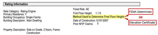
How Do I Know Which Method is Being Used to Rate My Policy?
Review the rating details on your NFIP policy declaration page to see the method being used.
- If it shows “Elevation Certificate,” then the data already on file from your property’s EC proved to be more favorable premium than the FEMA-determined data.
- If the method shows as “FEMA determined,” then you can complete the measurements on the EC yourself and submit the signed form to your agent.
Watch the Video
In this video, see what measurements you’ll need to take and how to complete them:
The Next Steps
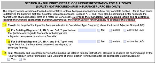
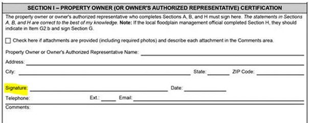
Click here to download the fillable EC form and follow the directions for completing Sections H and I.
- Section H applies to all flood zones and is used for NFIP policy rating only. It can be completed by anyone and contains only three questions.
- Section I is filled out and signed by the person who completed Section H, certifying the information entered on the form is accurate and true.
A few other things to note about the completed form:
- Section A (Property details/information) and Section B (Flood Insurance Rate Map information) must also be filled out. Contact your agent if you need help with any of the information.
- Clear photos of each side of the building are required (see pages 7 & 8 regarding Building Photographs).
- Provide the completed form to your agent. If the EC figures prove to be more beneficial and generate a lower premium, the data will be applied to the current term and reviewed at each renewal.
Should you have questions or need additional guidance on completing the Elevation Certificate form, contact your insurance agent for assistance.