
Flood Maps – Everything You Need to Know
Understanding your property’s flood risk is important, and the flood maps for your community play a big part. Whether you purchase your flood insurance through the National Flood Insurance Program (NFIP), or you find yourself investigating private market flood insurance reviews, understanding flood risk, flood maps, and how they are constantly shifting is an important way to protect your family.
So, what is a flood map? How are they made? Why and when are they updated? Here are the answers you need to get up to speed.
What is a Flood Map?
Flood maps inform the community about local flood risk, set minimum building standards to help keep the community safe and resilient, and help determine the cost of flood insurance.
The lower the risk a flood map shows, the lower flood insurance premiums are, and if a flood map shows high enough risk, you may be required by law to purchase flood insurance.
Engineering experts with the Federal Emergency Management Agency (FEMA) develop the maps based on sound science, taking into account:
- Hydrology
- Infrastructure
- Hydraulics
- Land Use
- Existing Maps (Floodplain, Base Map, Flood Map – if available)
They work with local communities at all steps of the process to integrate validated data and flood hazard information from the people and businesses that make up the community, which allows the community to review, appeal, and contribute to its own flood map, before it’s adopted.
Why are Flood Maps Important?
Flood Maps inform homeowners, businesses, and local communities of their risk of flood – potentially saving lives and damage to personal property. They also help control private market flood insurance costs and NFIP qualifications for communities across the nation.
Here are some facts to show just how important these maps can be:
- Flooding affects nearly 12.5 million square miles in all 50 states.
- Floods are the most common natural disaster in the U.S. and, since standard homeowner’s insurance doesn’t cover flooding, it’s important to have protection.
- People outside of mapped high-risk flood areas file more than 30% of all NFIP insurance claims.
How is a Flood Map Made?
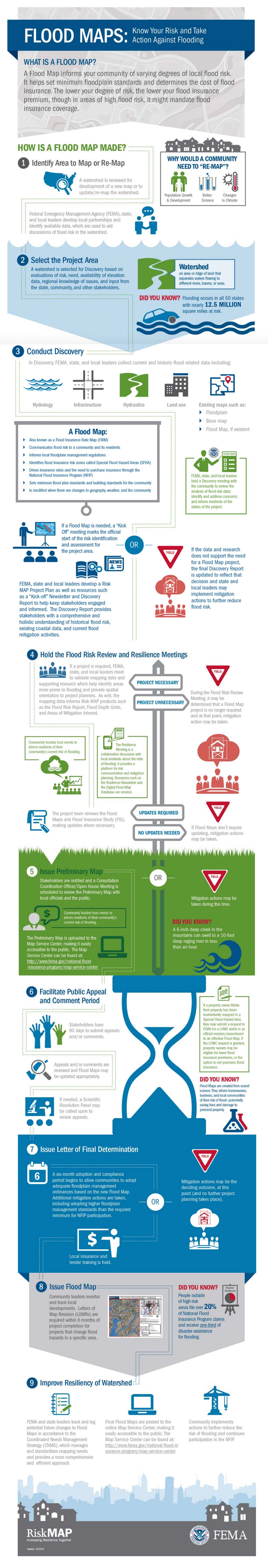
The flood mapping process is a thorough, comprehensive program made up of the nine steps below. To learn more about the process, and what’s involved in each step, check out FEMA’s “FLOOD MAPS: Know Your Risk and Take Action Against Flooding” infographic, below.
- Identify Area to Map or Re-Map
- Select the Project Area
- Gather Information
- Hold the Flood Risk Review and Resilience Meetings
- Issue Preliminary Map
- Facilitate Public Comment and Appeal Period
- Issue Letter of Final Determination
- Issue Flood Map
- Improve Resiliency of Watershed